
Superfast broadband update 29 March 2014 (revised 2nd April)
(With later slight revisions to tie in with other changes to this website)
The County Council now have a new website - http://www.superfastleicestershire.org.uk/ - which you should consult for more information and advice. This note is an attempt to distil things as they affect the Woodhouse Eaves telephone exchange area.
The County Council's website shows a revised map of expected developments county wide. We show a local extract of this. Please be aware that the mapping is still "high level" and definitely not definitive. We hope that more information will be available in a few months.
Before getting too excited we need to understand a little about the technology being deployed. The map shows (in green) areas which are expected be be able to receive a "fibre to the cabinet" (FTTC) broadband service. Only premises within about 1.2km of a fibre fed roadside cabinet (by telephone wire distance - generally along roads) will be able to receive true "superfast broadband" (SFBB), which the Government define as a 24mbps minimum download speed. Those further away, if they sign up to an FTTC service, will have lower speeds - possibly even as low a 2mbps at a distance. Our estimate of the limits of true SFBB is shown on the earlier map - see Summer 2013 report.
The extract of the new map is here. It would be sensible to interpret "from" in the notes as "not before". Please note also the comments below the map - it appears there could be major issues within Woodhouse Eaves.
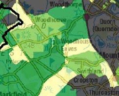 | The significant colours for us are:
|
The coverage areas are significantly different to the earlier version (see below). The following have been noted:
- The dark green now covers Warren Hill and the road between Swithland Triangle and Roecliffe Cross-roads, as well as Benscliffe Road and beyond - though one wonders what speeds will actually be available up near Old John as the copper cable runs will still be very long.
- Of concern to many in Woodhouse Eaves will be that an area apparently covering Birdhill Road, Herrick Road, Perry Close, Tuckett Road and possibly part of Maplewell Road appears to be "yellow" if you look closely. Investigation indicates that these roads are all fed directly from the exchange (no intervening cabinet to handle the fibre to copper transition). However, it appears to us that Beacon Road, Windmill Rise and half of Main Street also have "exchange only" lines though these all appear as light or dark green. We are seeking clarification (but see "Please be aware" above). We do understand that a new cabinet will intercept at least some of the "exchange only" lines.
- A large area to the north, sparsely populated and yellow on the earlier map, is now pale green. The status of premises on the north side of Dean's Lane is unclear. The value of having high speed broadband to the toilet blocks on Beacon Hill may be doubted.
- Roecliffe Road and Swithland Camp remain yellow. As they are served by the same cabinet as Warren Hill and are a similar distance from it, the logic escapes us.
- Brand Lane is in a yellow area possibly also including the Grange flats and Rushey Lane. The houses on Brand Lane are quite close to a cabinet, so we don't understand this either.
If your interpretation is different, or if you think anything should be added to this note, please email broadband at ruralweb dot org dot uk